


trace

GAPIAN43
User
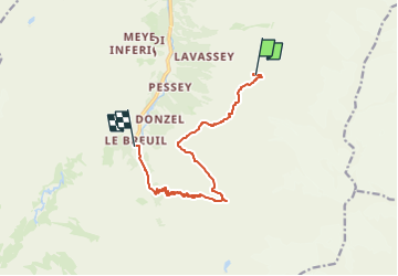

Length
10.6 km

Max alt
2719 m

Uphill gradient
295 m
Km-Effort
17 km

Min alt
1954 m

Downhill gradient
1034 m
Boucle
No
Creation date :
2024-05-21 08:06:04.536
Updated on :
2024-05-21 08:07:15.185
3h51
Difficulty : Medium

FREE GPS app for hiking
 SityTrail
IGN / Geographical institutes
SityTrail Plus
The world is yours!
About
Trail Walking of 10.6 km to be discovered at Aosta Valley, Unknown, Valsavarenche. This trail is proposed by GAPIAN43.
Description
Grand Paradis 2024 - Jour 2 - Refuge Chabot -> Refuge Emmanuel -> Pont
Positioning
Country:
Italy
Region :
Aosta Valley
Department/Province :
Unknown
Municipality :
Valsavarenche
Location:
Unknown
Start:(Dec)
Start:(UTM)
362511 ; 5044469 (32T) N.
Comments