


trace

GAPIAN43
User
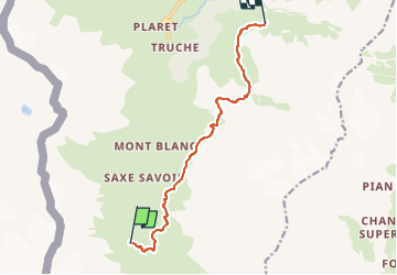

Length
9.6 km

Max alt
2657 m

Uphill gradient
672 m
Km-Effort
18.3 km

Min alt
2278 m

Downhill gradient
590 m
Boucle
No
Creation date :
2024-05-21 08:11:44.955
Updated on :
2024-05-21 08:16:29.612
4h08
Difficulty : Difficult

FREE GPS app for hiking
 SityTrail
IGN / Geographical institutes
SityTrail Plus
The world is yours!
About
Trail Walking of 9.6 km to be discovered at Aosta Valley, Unknown, Valgrisenche. This trail is proposed by GAPIAN43.
Positioning
Country:
Italy
Region :
Aosta Valley
Department/Province :
Unknown
Municipality :
Valgrisenche
Location:
Unknown
Start:(Dec)
Start:(UTM)
345260 ; 5044937 (32T) N.
Comments