


trace

GAPIAN43
User
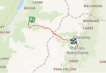

Length
7 km

Max alt
2852 m

Uphill gradient
474 m
Km-Effort
15.5 km

Min alt
1723 m

Downhill gradient
1121 m
Boucle
No
Creation date :
2024-05-21 08:13:02.163
Updated on :
2024-05-21 08:18:35.107
3h31
Difficulty : Medium

FREE GPS app for hiking
 SityTrail
IGN / Geographical institutes
SityTrail Plus
The world is yours!
About
Trail Walking of 7 km to be discovered at Aosta Valley, Unknown, Valgrisenche. This trail is proposed by GAPIAN43.
Description
Grand Paradis 2024 - Jour 6 - Ref de l'Epée -> Rhemes Notre Dame par col de la Fenetre
Positioning
Country:
Italy
Region :
Aosta Valley
Department/Province :
Unknown
Municipality :
Valgrisenche
Location:
Unknown
Start:(Dec)
Start:(UTM)
348688 ; 5050195 (32T) N.
Comments