


Croix de Meyrieu

Chabard
User
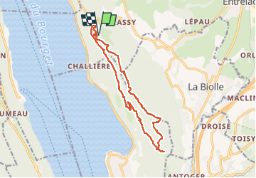

Length
16.1 km

Max alt
843 m

Uphill gradient
716 m
Km-Effort
26 km

Min alt
514 m

Downhill gradient
714 m
Boucle
Yes
Creation date :
2024-05-21 07:55:24.0
Updated on :
2024-05-21 17:09:34.253
5h49
Difficulty : Medium

FREE GPS app for hiking
 SityTrail
IGN / Geographical institutes
SityTrail Plus
The world is yours!
About
Trail Walking of 16.1 km to be discovered at Auvergne-Rhône-Alpes, Savoy, Entrelacs. This trail is proposed by Chabard.
Description
Col de la Chambotte - tunnel - Granges de Brison - Grotte des Fées - Ferme Gigot - Croix de Meyrieu - Retour la Chambotte
Positioning
Country:
France
Region :
Auvergne-Rhône-Alpes
Department/Province :
Savoy
Municipality :
Entrelacs
Location:
Saint-Germain-la-Chambotte
Start:(Dec)
Start:(UTM)
723598 ; 5072950 (31T) N.
Comments