


lescar CarolinRS

LouisROGER
User GUIDE
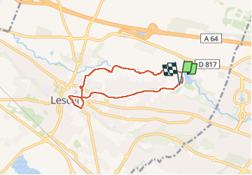

Length
6.3 km

Max alt
193 m

Uphill gradient
43 m
Km-Effort
6.9 km

Min alt
171 m

Downhill gradient
42 m
Boucle
Yes
Creation date :
2024-05-21 12:17:54.25
Updated on :
2024-05-21 15:20:17.305
3h01
Difficulty : Medium

FREE GPS app for hiking
 SityTrail
IGN / Geographical institutes
SityTrail Plus
The world is yours!
About
Trail Walking of 6.3 km to be discovered at New Aquitaine, Pyrénées-Atlantiques, Lescar. This trail is proposed by LouisROGER.
Positioning
Country:
France
Region :
New Aquitaine
Department/Province :
Pyrénées-Atlantiques
Municipality :
Lescar
Location:
Unknown
Start:(Dec)
Start:(UTM)
710156 ; 4801430 (30T) N.
Comments