


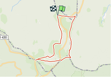
Uff Rain/ Hahnenbrunnen

geoffrayLayeux
User

Length
7 km

Max alt
1307 m

Uphill gradient
197 m
Km-Effort
9.6 km

Min alt
1159 m

Downhill gradient
199 m
Boucle
Yes
Creation date :
2024-05-21 16:56:29.383
Updated on :
2024-05-21 16:58:21.896
2h10
Difficulty : Medium

FREE GPS app for hiking
 SityTrail
IGN / Geographical institutes
SityTrail Plus
The world is yours!
About
Trail Walking of 7 km to be discovered at Grand Est, Haut-Rhin, Metzeral. This trail is proposed by geoffrayLayeux.
Positioning
Country:
France
Region :
Grand Est
Department/Province :
Haut-Rhin
Municipality :
Metzeral
Location:
Unknown
Start:(Dec)
Start:(UTM)
353121 ; 5314677 (32T) N.
Comments