


VTT Roquefort Fontmerle

GrouGary
User

Length
33 km

Max alt
215 m

Uphill gradient
619 m
Km-Effort
41 km

Min alt
71 m

Downhill gradient
608 m
Boucle
Yes
Creation date :
2015-04-11 00:00:00.0
Updated on :
2015-04-11 00:00:00.0
3h32
Difficulty : Medium

FREE GPS app for hiking
 SityTrail
IGN / Geographical institutes
SityTrail Plus
The world is yours!
About
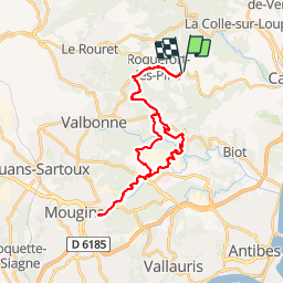
Trail Mountain bike of 33 km to be discovered at Provence-Alpes-Côte d'Azur, Maritime Alps, Roquefort-les-Pins. This trail is proposed by GrouGary.
Description
Tamarins-auberge Source-tour golf Mougins-Fontmerle-Airfrance -bois Roquefort
Positioning
Country:
France
Region :
Provence-Alpes-Côte d'Azur
Department/Province :
Maritime Alps
Municipality :
Roquefort-les-Pins
Location:
Unknown
Start:(Dec)
Start:(UTM)
344020 ; 4836362 (32T) N.
Comments
5
- Juste un petit loupe au début du circuit , ce qui explique la différence des dénivelés + et - : le GPS n'a pas geolocalise immédiatement. .. d'où l'écart de 300 M - Retour rapide par la route, mais une belle variante apres Airfrance, dans les bois, pour rejoindre Valbonne....et rentrer sur Roquefort par la route