Trail Mountain bike Roquefort-les-Pins - VTT Roquefort Fontmerle - Photo
 GrouGary
GrouGary

User

© OpenStreetMap contributors
Length
Length
33 km
Max alt
Max alt
215 m
Uphill gradient
Uphill gradient
619 m
Km-Effort
Km-Effort  
41 km
Min alt
Min alt
71 m
Downhill gradient
Downhill gradient
608 m
Boucle
Boucle
Yes
Creation date :
2015-04-11 00:00:00.0
Updated on :
2015-04-11 00:00:00.0

(3 Reviews)

Mountain bike
Mountain bike
3h32
Difficulty : Medium

Scan this QR Code to open this trail in the SityTrail application

FREE GPS app for hiking

Logo SityTrail SityTrail

IGN / Geographical institutes

Download SityTrail from the App Store Download SityTrail from Google Play

Logo SityTrail SityTrail World

The world is yours!

Download SityTrail from the App Store Download SityTrail from Google Play Download SityTrail on Huawei AppGallery

About

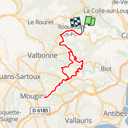
Trail Mountain bike of 33 km to be discovered at Provence-Alpes-Côte d'Azur, Maritime Alps, Roquefort-les-Pins. This trail is proposed by GrouGary.

Description

Tamarins-auberge Source-tour golf Mougins-Fontmerle-Airfrance -bois Roquefort

Elevation profile

Positioning

Country:
France
Region :
Provence-Alpes-Côte d'Azur
Department/Province :
Maritime Alps
Municipality :
Roquefort-les-Pins
Location:
Unknown
Start:(UTM)
344020 ; 4836362 (32T) N.

Comments

Please log in to post a review or rate the element


5


- Juste un petit loupe au début du circuit , ce qui explique la différence des dénivelés + et - : le GPS n'a pas geolocalise immédiatement. .. d'où l'écart de 300 M - Retour rapide par la route, mais une belle variante apres Airfrance, dans les bois, pour rejoindre Valbonne....et rentrer sur Roquefort par la route


Trails nearby

Trail On foot Le Rouret - Le Camp romain - Photo
On foot
PRO

On foot

Easy
Le Rouret, Provence-Alpes-Côte d'Azur, Maritime Alps, France
6.8 km | 9.6 km-effort
2h 10min
Yes
Trail On foot Roquefort-les-Pins - Le Rucher - Photo
On foot
PRO

On foot

Easy
Roquefort-les-Pins, Provence-Alpes-Côte d'Azur, Maritime Alps, France
3.7 km | 4.8 km-effort
1h 5min
No
Trail On foot Biot - Sentier de la Vallée de la Brague - Photo
On foot
PRO

On foot

Easy
Biot, Provence-Alpes-Côte d'Azur, Maritime Alps, France
10 km | 12.5 km-effort
2h 50min
No
Trail On foot Valbonne - Circuit des Macarons - Photo
On foot
PRO

On foot

Easy
Valbonne, Provence-Alpes-Côte d'Azur, Maritime Alps, France
6.3 km | 8.6 km-effort
1h 57min
Yes
Trail On foot Valbonne - Circuit des Bouillides - Photo
On foot
PRO

On foot

Easy
Valbonne, Provence-Alpes-Côte d'Azur, Maritime Alps, France
10.6 km | 13.9 km-effort
3h 8min
Yes
Trail On foot Valbonne - Circuit du Bruguet - Photo
On foot
PRO

On foot

Easy
Valbonne, Provence-Alpes-Côte d'Azur, Maritime Alps, France
7.2 km | 9.4 km-effort
2h 7min
Yes
Trail On foot Biot - Circuit de Saint-Philippe - Photo
On foot
PRO

On foot

Easy
Biot, Provence-Alpes-Côte d'Azur, Maritime Alps, France
3.3 km | 4.7 km-effort
1h 4min
No
Trail On foot Biot - Circuit des Pierres à Four - Photo
On foot
PRO

On foot

Easy
Biot, Provence-Alpes-Côte d'Azur, Maritime Alps, France
10.3 km | 13 km-effort
2h 57min
Yes
Trail On foot Roquefort-les-Pins - Circuit de Darbousson - Photo
On foot
PRO

On foot

Easy
Roquefort-les-Pins, Provence-Alpes-Côte d'Azur, Maritime Alps, France
9.2 km | 11.8 km-effort
2h 40min
Yes


Close
My subscriptions