26/05/24

rolandwin
User

Length
41 km

Max alt
397 m

Uphill gradient
456 m
Km-Effort
47 km

Min alt
296 m

Downhill gradient
453 m
Boucle
Yes
Creation date :
2024-05-26 11:56:03.206
Updated on :
2024-05-28 11:20:51.127
2h18
Difficulty : Medium

FREE GPS app for hiking
 SityTrail
IGN / Geographical institutes
SityTrail Plus
The world is yours!
About
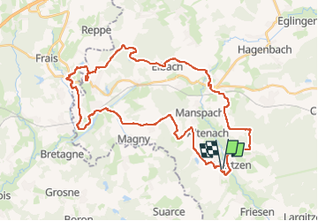
Trail Mountain bike of 41 km to be discovered at Grand Est, Haut-Rhin, Mertzen. This trail is proposed by rolandwin.
Positioning
Country:
France
Region :
Grand Est
Department/Province :
Haut-Rhin
Municipality :
Mertzen
Location:
Unknown
Start:(Dec)
Start:(UTM)
358939 ; 5272191 (32T) N.
Comments