


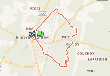
retjons, prit, chicoy, caplanne, carreyre, miconine - 8.1

hartmannpat
User

Length
8.1 km

Max alt
89 m

Uphill gradient
68 m
Km-Effort
9 km

Min alt
62 m

Downhill gradient
67 m
Boucle
Yes
Creation date :
2024-05-30 07:02:33.254
Updated on :
2024-05-30 09:26:46.106
2h03
Difficulty : Medium

FREE GPS app for hiking
 SityTrail
IGN / Geographical institutes
SityTrail Plus
The world is yours!
About
Trail Walking of 8.1 km to be discovered at New Aquitaine, Landes, Rion-des-Landes. This trail is proposed by hartmannpat.
Positioning
Country:
France
Region :
New Aquitaine
Department/Province :
Landes
Municipality :
Rion-des-Landes
Location:
Rion-des-Landes
Start:(Dec)
Start:(UTM)
666944 ; 4866623 (30T) N.
Comments