


Étape 3 juin 2024

Pascal Bernaud
User

Length
21 km

Max alt
776 m

Uphill gradient
448 m
Km-Effort
27 km

Min alt
500 m

Downhill gradient
253 m
Boucle
No
Creation date :
2024-06-03 06:32:49.0
Updated on :
2024-06-04 06:03:42.736
7h09
Difficulty : Very difficult

FREE GPS app for hiking
 SityTrail
IGN / Geographical institutes
SityTrail Plus
The world is yours!
About
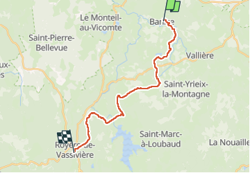
Trail Walking of 21 km to be discovered at New Aquitaine, Creuse, Banize. This trail is proposed by Pascal Bernaud.
Positioning
Country:
France
Region :
New Aquitaine
Department/Province :
Creuse
Municipality :
Banize
Location:
Unknown
Start:(Dec)
Start:(UTM)
422383 ; 5086822 (31T) N.
Comments