


TRK000

JCLUTT
User
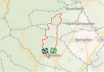

Length
12.8 km

Max alt
745 m

Uphill gradient
503 m
Km-Effort
19.5 km

Min alt
348 m

Downhill gradient
500 m
Boucle
Yes
Creation date :
2024-06-05 07:31:33.131
Updated on :
2024-06-05 07:36:00.714
4h25
Difficulty : Very difficult

FREE GPS app for hiking
 SityTrail
IGN / Geographical institutes
SityTrail Plus
The world is yours!
About
Trail Walking of 12.8 km to be discovered at Grand Est, Haut-Rhin, Wattwiller. This trail is proposed by JCLUTT.
Positioning
Country:
France
Region :
Grand Est
Department/Province :
Haut-Rhin
Municipality :
Wattwiller
Location:
Unknown
Start:(Dec)
Start:(UTM)
363584 ; 5299664 (32T) N.
Comments