


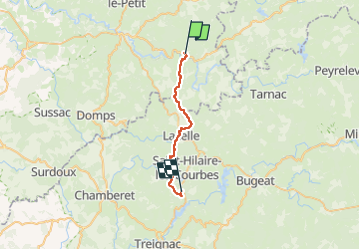
Étape 5 juin 2024

Pascal Bernaud
User

Length
24 km

Max alt
739 m

Uphill gradient
601 m
Km-Effort
32 km

Min alt
486 m

Downhill gradient
495 m
Boucle
No
Creation date :
2024-06-05 05:41:44.0
Updated on :
2024-06-05 13:50:27.825
8h07
Difficulty : Very difficult

FREE GPS app for hiking
 SityTrail
IGN / Geographical institutes
SityTrail Plus
The world is yours!
About
Trail Walking of 24 km to be discovered at New Aquitaine, Haute-Vienne, Nedde. This trail is proposed by Pascal Bernaud.
Positioning
Country:
France
Region :
New Aquitaine
Department/Province :
Haute-Vienne
Municipality :
Nedde
Location:
Unknown
Start:(Dec)
Start:(UTM)
409073 ; 5063622 (31T) N.
Comments