modif du 15

favraux
User
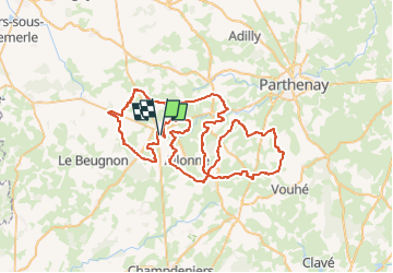

Length
80 km

Max alt
242 m

Uphill gradient
878 m
Km-Effort
92 km

Min alt
148 m

Downhill gradient
877 m
Boucle
Yes
Creation date :
2024-06-08 10:20:05.596
Updated on :
2024-06-14 19:33:55.057
7h03
Difficulty : Very easy

FREE GPS app for hiking
 SityTrail
IGN / Geographical institutes
SityTrail Plus
The world is yours!
About
Trail Quad of 80 km to be discovered at New Aquitaine, Deux-Sèvres, Secondigny. This trail is proposed by favraux.
Positioning
Country:
France
Region :
New Aquitaine
Department/Province :
Deux-Sèvres
Municipality :
Secondigny
Location:
Unknown
Start:(Dec)
Start:(UTM)
697989 ; 5164450 (30T) N.
Comments