


Vallée de l'Ourthe, jour 3 : Hamoir à Bomal

MathieuBourgois
User
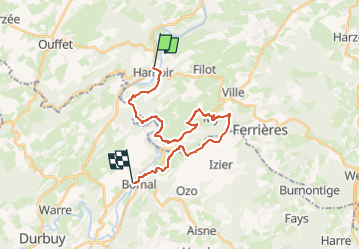

Length
21 km

Max alt
267 m

Uphill gradient
539 m
Km-Effort
28 km

Min alt
114 m

Downhill gradient
524 m
Boucle
No
Creation date :
2024-06-11 07:46:33.232
Updated on :
2024-06-11 07:56:00.968
6h24
Difficulty : Medium

FREE GPS app for hiking
 SityTrail
IGN / Geographical institutes
SityTrail Plus
The world is yours!
About
Trail On foot of 21 km to be discovered at Wallonia, Liège, Hamoir. This trail is proposed by MathieuBourgois.
Description
My 12km et 400D
Positioning
Country:
Belgium
Region :
Wallonia
Department/Province :
Liège
Municipality :
Hamoir
Location:
Unknown
Start:(Dec)
Start:(UTM)
679949 ; 5589234 (31U) N.
Comments