


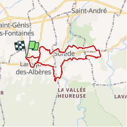
LAROQUE - Mas MANYERES - SOREDE - Mas Linas - SOREDE

jeff66
User

Length
15.8 km

Max alt
161 m

Uphill gradient
203 m
Km-Effort
18.5 km

Min alt
60 m

Downhill gradient
203 m
Boucle
Yes
Creation date :
2015-04-17 00:00:00.0
Updated on :
2015-04-17 00:00:00.0
2h48
Difficulty : Easy

FREE GPS app for hiking
 SityTrail
IGN / Geographical institutes
SityTrail Plus
The world is yours!
About
Trail Walking of 15.8 km to be discovered at Occitania, Pyrénées-Orientales, Laroque-des-Albères. This trail is proposed by jeff66.
Description
LAROQUE - ch. de Tanya - Mas MANYERES - SOREDE - Riviere de SOREDE - Mas del ROSTH - Mas Linas - SOREDE - quartier de la Coscolleda - laroque
Points of interest


Positioning
Country:
France
Region :
Occitania
Department/Province :
Pyrénées-Orientales
Municipality :
Laroque-des-Albères
Location:
Unknown
Start:(Dec)
Start:(UTM)
494301 ; 4708450 (31T) N.
Comments