


retjons,prit,carreyre (détail)

hartmannpat
User
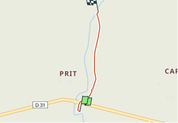

Length
396 m

Max alt
78 m

Uphill gradient
2 m
Km-Effort
416 m

Min alt
73 m

Downhill gradient
0 m
Boucle
No
Creation date :
2024-06-14 05:38:32.325
Updated on :
2024-06-14 05:49:00.286
5m
Difficulty : Easy

FREE GPS app for hiking
 SityTrail
IGN / Geographical institutes
SityTrail Plus
The world is yours!
About
Trail Walking of 396 m to be discovered at New Aquitaine, Landes, Rion-des-Landes. This trail is proposed by hartmannpat.
Positioning
Country:
France
Region :
New Aquitaine
Department/Province :
Landes
Municipality :
Rion-des-Landes
Location:
Rion-des-Landes
Start:(Dec)
Start:(UTM)
668302 ; 4866692 (30T) N.
Comments