


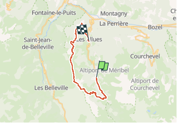
chaudane - les Allues, par les cretes et le col de jean

XavierFaidix
User

Length
19.5 km

Max alt
2284 m

Uphill gradient
879 m
Km-Effort
32 km

Min alt
1112 m

Downhill gradient
1200 m
Boucle
No
Creation date :
2024-06-16 12:19:55.9
Updated on :
2024-06-16 15:44:13.46
2h22
Difficulty : Medium

FREE GPS app for hiking
 SityTrail
IGN / Geographical institutes
SityTrail Plus
The world is yours!
About
Trail Mountain bike of 19.5 km to be discovered at Auvergne-Rhône-Alpes, Savoy, Les Allues. This trail is proposed by XavierFaidix.
Description
VAE
Positioning
Country:
France
Region :
Auvergne-Rhône-Alpes
Department/Province :
Savoy
Municipality :
Les Allues
Location:
Unknown
Start:(Dec)
Start:(UTM)
309597 ; 5029541 (32T) N.
Comments