


Amuré

olaze
User
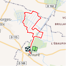

Length
7.4 km

Max alt
12 m

Uphill gradient
37 m
Km-Effort
7.9 km

Min alt
2 m

Downhill gradient
37 m
Boucle
Yes
Creation date :
2017-03-28 00:00:00.0
Updated on :
2017-03-28 00:00:00.0
1h45
Difficulty : Very easy

FREE GPS app for hiking
 SityTrail
IGN / Geographical institutes
SityTrail Plus
The world is yours!
About
Trail Walking of 7.4 km to be discovered at New Aquitaine, Deux-Sèvres, Amuré. This trail is proposed by olaze.
Positioning
Country:
France
Region :
New Aquitaine
Department/Province :
Deux-Sèvres
Municipality :
Amuré
Location:
Unknown
Start:(Dec)
Start:(UTM)
682423 ; 5126078 (30T) N.
Comments