


mande saint etienne

jfmartin1978
User
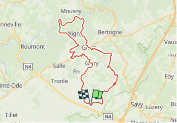

Length
34 km

Max alt
492 m

Uphill gradient
692 m
Km-Effort
43 km

Min alt
309 m

Downhill gradient
696 m
Boucle
Yes
Creation date :
2024-06-18 19:12:10.496
Updated on :
2024-06-18 19:13:06.472
9h44
Difficulty : Very difficult

FREE GPS app for hiking
 SityTrail
IGN / Geographical institutes
SityTrail Plus
The world is yours!
About
Trail Walking of 34 km to be discovered at Wallonia, Luxembourg, Bertogne. This trail is proposed by jfmartin1978.
Positioning
Country:
Belgium
Region :
Wallonia
Department/Province :
Luxembourg
Municipality :
Bertogne
Location:
Unknown
Start:(Dec)
Start:(UTM)
689182 ; 5544004 (31U) N.
Comments