


traçage Livron 2024

LouisROGER
User GUIDE
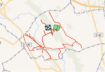

Length
25 km

Max alt
425 m

Uphill gradient
286 m
Km-Effort
29 km

Min alt
316 m

Downhill gradient
292 m
Boucle
Yes
Creation date :
2024-06-24 08:59:47.866
Updated on :
2024-06-24 17:15:45.225
2h56
Difficulty : Medium

FREE GPS app for hiking
 SityTrail
IGN / Geographical institutes
SityTrail Plus
The world is yours!
About
Trail Mountain bike of 25 km to be discovered at New Aquitaine, Pyrénées-Atlantiques, Livron. This trail is proposed by LouisROGER.
Positioning
Country:
France
Region :
New Aquitaine
Department/Province :
Pyrénées-Atlantiques
Municipality :
Livron
Location:
Unknown
Start:(Dec)
Start:(UTM)
732649 ; 4790607 (30T) N.
Comments