


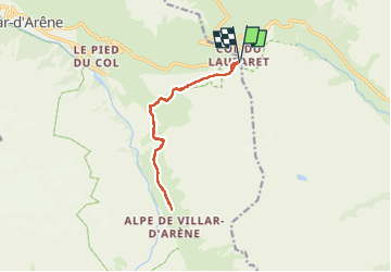
Plan de l'Alpe (Villard d'Arène 05)

Clo0413
User

Length
12.5 km

Max alt
2131 m

Uphill gradient
339 m
Km-Effort
17 km

Min alt
2023 m

Downhill gradient
339 m
Boucle
Yes
Creation date :
2024-06-26 08:26:04.245
Updated on :
2024-07-16 10:19:38.09
3h51
Difficulty : Medium

FREE GPS app for hiking
 SityTrail
IGN / Geographical institutes
SityTrail Plus
The world is yours!
About
Trail Walking of 12.5 km to be discovered at Provence-Alpes-Côte d'Azur, Hautes-Alpes, Villar-d'Arêne. This trail is proposed by Clo0413.
Positioning
Country:
France
Region :
Provence-Alpes-Côte d'Azur
Department/Province :
Hautes-Alpes
Municipality :
Villar-d'Arêne
Location:
Unknown
Start:(Dec)
Start:(UTM)
295654 ; 4989965 (32T) N.
Comments