


Refuge des Cortalets - Taurinya

GeorgesV.
User
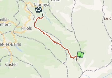

Length
10 km

Max alt
2153 m

Uphill gradient
0 m
Km-Effort
15 km

Min alt
638 m

Downhill gradient
1506 m
Boucle
No
Creation date :
2024-06-27 05:42:47.0
Updated on :
2024-06-27 09:46:31.753

FREE GPS app for hiking
 SityTrail
IGN / Geographical institutes
SityTrail Plus
The world is yours!
About
Trail of 10 km to be discovered at Occitania, Pyrénées-Orientales, Taurinya. This trail is proposed by GeorgesV..
Description
Canigou - retour vers le gîte de Taurinya
Positioning
Country:
France
Region :
Occitania
Department/Province :
Pyrénées-Orientales
Municipality :
Taurinya
Location:
Unknown
Start:(Dec)
Start:(UTM)
456094 ; 4709257 (31T) N.
Comments