


lac vert, lac du forlet

Alain28/01
User
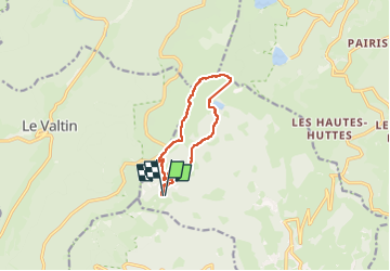

Length
10 km

Max alt
1300 m

Uphill gradient
435 m
Km-Effort
15.8 km

Min alt
1053 m

Downhill gradient
433 m
Boucle
Yes
Creation date :
2024-06-28 08:12:39.404
Updated on :
2024-06-28 14:18:55.655
2h52
Difficulty : Medium

FREE GPS app for hiking
 SityTrail
IGN / Geographical institutes
SityTrail Plus
The world is yours!
About
Trail Walking of 10 km to be discovered at Grand Est, Haut-Rhin, Soultzeren. This trail is proposed by Alain28/01.
Positioning
Country:
France
Region :
Grand Est
Department/Province :
Haut-Rhin
Municipality :
Soultzeren
Location:
Unknown
Start:(Dec)
Start:(UTM)
355556 ; 5327393 (32U) N.
Comments