


Mantet

JeanPierreNancy
User
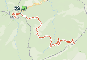

Length
34 km

Max alt
2254 m

Uphill gradient
985 m
Km-Effort
48 km

Min alt
1535 m

Downhill gradient
992 m
Boucle
Yes
Creation date :
2024-06-28 09:21:06.875
Updated on :
2024-06-28 15:16:28.415
5h04
Difficulty : Very difficult

FREE GPS app for hiking
 SityTrail
IGN / Geographical institutes
SityTrail Plus
The world is yours!
About
Trail Mountain bike of 34 km to be discovered at Occitania, Pyrénées-Orientales, Py. This trail is proposed by JeanPierreNancy.
Positioning
Country:
France
Region :
Occitania
Department/Province :
Pyrénées-Orientales
Municipality :
Py
Location:
Unknown
Start:(Dec)
Start:(UTM)
443656 ; 4703418 (31T) N.
Comments