


Pla de Bones Hores

GeorgesV.
User
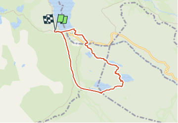

Length
6.9 km

Max alt
2044 m

Uphill gradient
191 m
Km-Effort
9.5 km

Min alt
1943 m

Downhill gradient
189 m
Boucle
Yes
Creation date :
2024-06-29 19:28:18.0
Updated on :
2024-08-16 06:52:29.532
2h09
Difficulty : Easy

FREE GPS app for hiking
 SityTrail
IGN / Geographical institutes
SityTrail Plus
The world is yours!
About
Trail Walking of 6.9 km to be discovered at Occitania, Pyrénées-Orientales, Angoustrine-Villeneuve-des-Escaldes. This trail is proposed by GeorgesV..
Positioning
Country:
France
Region :
Occitania
Department/Province :
Pyrénées-Orientales
Municipality :
Angoustrine-Villeneuve-des-Escaldes
Location:
Unknown
Start:(Dec)
Start:(UTM)
417642 ; 4712467 (31T) N.
Comments