


lacs blanc et 5 lacs de bellecombe

trusgnachjf
User
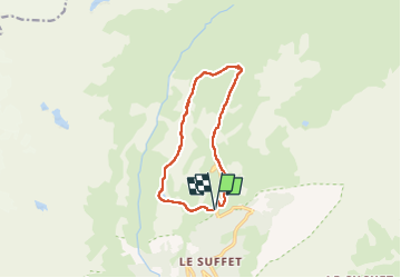

Length
11.3 km

Max alt
2445 m

Uphill gradient
478 m
Km-Effort
17.7 km

Min alt
2051 m

Downhill gradient
472 m
Boucle
Yes
Creation date :
2024-06-30 07:30:05.234
Updated on :
2024-06-30 14:05:21.173
6h34
Difficulty : Difficult

FREE GPS app for hiking
 SityTrail
IGN / Geographical institutes
SityTrail Plus
The world is yours!
About
Trail Walking of 11.3 km to be discovered at Auvergne-Rhône-Alpes, Savoy, Val-Cenis. This trail is proposed by trusgnachjf.
Positioning
Country:
France
Region :
Auvergne-Rhône-Alpes
Department/Province :
Savoy
Municipality :
Val-Cenis
Location:
Termignon
Start:(Dec)
Start:(UTM)
329898 ; 5020264 (32T) N.
Comments