


aller plan des fouilles orelle

JPS73
User
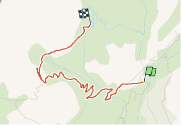

Length
4.4 km

Max alt
2533 m

Uphill gradient
504 m
Km-Effort
9.5 km

Min alt
2046 m

Downhill gradient
30 m
Boucle
No
Creation date :
2024-07-04 08:11:45.199
Updated on :
2024-07-04 10:35:41.279
1h49
Difficulty : Medium

FREE GPS app for hiking
 SityTrail
IGN / Geographical institutes
SityTrail Plus
The world is yours!
About
Trail Walking of 4.4 km to be discovered at Auvergne-Rhône-Alpes, Savoy, Orelle. This trail is proposed by JPS73.
Positioning
Country:
France
Region :
Auvergne-Rhône-Alpes
Department/Province :
Savoy
Municipality :
Orelle
Location:
Unknown
Start:(Dec)
Start:(UTM)
308286 ; 5012162 (32T) N.
Comments