


Pralo5

binard
User
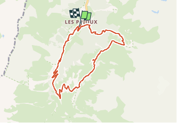

Length
9.5 km

Max alt
2206 m

Uphill gradient
517 m
Km-Effort
16.4 km

Min alt
1713 m

Downhill gradient
521 m
Boucle
Yes
Creation date :
2024-07-04 09:08:26.619
Updated on :
2024-07-05 18:04:35.655
3h43
Difficulty : Difficult

FREE GPS app for hiking
 SityTrail
IGN / Geographical institutes
SityTrail Plus
The world is yours!
About
Trail Walking of 9.5 km to be discovered at Auvergne-Rhône-Alpes, Savoy, Pralognan-la-Vanoise. This trail is proposed by binard.
Positioning
Country:
France
Region :
Auvergne-Rhône-Alpes
Department/Province :
Savoy
Municipality :
Pralognan-la-Vanoise
Location:
Unknown
Start:(Dec)
Start:(UTM)
319923 ; 5023999 (32T) N.
Comments