


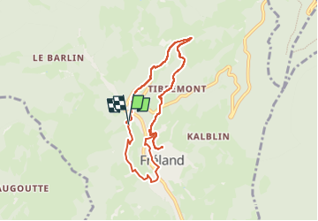
Sentier découverte Fréland

duchaine.nicolas
User

Length
6.8 km

Max alt
687 m

Uphill gradient
393 m
Km-Effort
12.1 km

Min alt
418 m

Downhill gradient
386 m
Boucle
Yes
Creation date :
2024-07-07 09:52:02.586
Updated on :
2024-07-10 11:58:08.108
2h44
Difficulty : Difficult

FREE GPS app for hiking
 SityTrail
IGN / Geographical institutes
SityTrail Plus
The world is yours!
About
Trail Walking of 6.8 km to be discovered at Grand Est, Haut-Rhin, Fréland. This trail is proposed by duchaine.nicolas.
Positioning
Country:
France
Region :
Grand Est
Department/Province :
Haut-Rhin
Municipality :
Fréland
Location:
Unknown
Start:(Dec)
Start:(UTM)
365309 ; 5337530 (32U) N.
Comments