


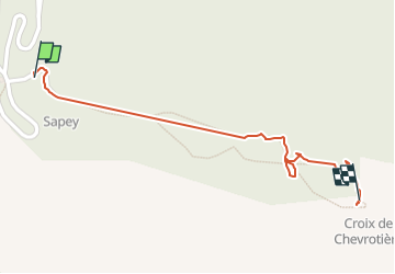
Croix au dessus de Jarrier

verozerr
User

Length
782 m

Max alt
1550 m

Uphill gradient
9 m
Km-Effort
955 m

Min alt
1506 m

Downhill gradient
25 m
Boucle
No
Creation date :
2024-07-07 12:38:27.339
Updated on :
2024-07-07 14:05:26.476
1h26
Difficulty : Easy

FREE GPS app for hiking
 SityTrail
IGN / Geographical institutes
SityTrail Plus
The world is yours!
About
Trail Walking of 782 m to be discovered at Auvergne-Rhône-Alpes, Savoy, Jarrier. This trail is proposed by verozerr.
Description
parking du Sapey
Positioning
Country:
France
Region :
Auvergne-Rhône-Alpes
Department/Province :
Savoy
Municipality :
Jarrier
Location:
Unknown
Start:(Dec)
Start:(UTM)
290382 ; 5018725 (32T) N.
Comments