


Corrençon en bas et en haut

fdm1
User
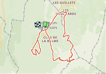

Length
24 km

Max alt
2128 m

Uphill gradient
1236 m
Km-Effort
41 km

Min alt
1088 m

Downhill gradient
1237 m
Boucle
Yes
Creation date :
2024-07-08 08:40:57.816
Updated on :
2024-07-08 15:46:43.924
6h46
Difficulty : Medium

FREE GPS app for hiking
 SityTrail
IGN / Geographical institutes
SityTrail Plus
The world is yours!
About
Trail Walking of 24 km to be discovered at Auvergne-Rhône-Alpes, Isère, Corrençon-en-Vercors. This trail is proposed by fdm1.
Positioning
Country:
France
Region :
Auvergne-Rhône-Alpes
Department/Province :
Isère
Municipality :
Corrençon-en-Vercors
Location:
Unknown
Start:(Dec)
Start:(UTM)
698576 ; 4989002 (31T) N.
Comments