


aoste les saisies

Nancy Arpaia
User
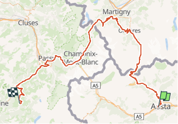

Length
182 km

Max alt
2478 m

Uphill gradient
6085 m
Km-Effort
260 km

Min alt
554 m

Downhill gradient
4988 m
Boucle
No
Creation date :
2024-07-10 11:05:40.523
Updated on :
2024-07-10 11:15:53.636
0m
Difficulty : Very easy

FREE GPS app for hiking
 SityTrail
IGN / Geographical institutes
SityTrail Plus
The world is yours!
About
Trail Motorbike of 182 km to be discovered at Aosta Valley, Unknown, Aosta. This trail is proposed by Nancy Arpaia.
Positioning
Country:
Italy
Region :
Aosta Valley
Department/Province :
Unknown
Municipality :
Aosta
Location:
Unknown
Start:(Dec)
Start:(UTM)
368007 ; 5065827 (32T) N.
Comments