


col des bataillières boucle

geoffrayLayeux
User
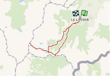

Length
15.3 km

Max alt
2780 m

Uphill gradient
874 m
Km-Effort
27 km

Min alt
1907 m

Downhill gradient
874 m
Boucle
Yes
Creation date :
2024-07-10 15:54:03.038
Updated on :
2024-07-10 15:54:15.25
6h07
Difficulty : Very difficult

FREE GPS app for hiking
 SityTrail
IGN / Geographical institutes
SityTrail Plus
The world is yours!
About
Trail Walking of 15.3 km to be discovered at Auvergne-Rhône-Alpes, Savoy, Modane. This trail is proposed by geoffrayLayeux.
Positioning
Country:
France
Region :
Auvergne-Rhône-Alpes
Department/Province :
Savoy
Municipality :
Modane
Location:
Unknown
Start:(Dec)
Start:(UTM)
314062 ; 5002260 (32T) N.
Comments