


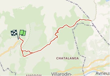
col du Barbier

geoffrayLayeux
User

Length
10.6 km

Max alt
2361 m

Uphill gradient
666 m
Km-Effort
19.5 km

Min alt
1823 m

Downhill gradient
663 m
Boucle
Yes
Creation date :
2024-07-10 16:04:43.863
Updated on :
2024-07-10 16:04:49.272
4h26
Difficulty : Very difficult

FREE GPS app for hiking
 SityTrail
IGN / Geographical institutes
SityTrail Plus
The world is yours!
About
Trail Walking of 10.6 km to be discovered at Auvergne-Rhône-Alpes, Savoy, Villarodin-Bourget. This trail is proposed by geoffrayLayeux.
Positioning
Country:
France
Region :
Auvergne-Rhône-Alpes
Department/Province :
Savoy
Municipality :
Villarodin-Bourget
Location:
Unknown
Start:(Dec)
Start:(UTM)
317284 ; 5010999 (32T) N.
Comments