


Beblenheim - Colmar

zazie
User
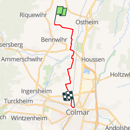

Length
12 km

Max alt
214 m

Uphill gradient
62 m
Km-Effort
12.9 km

Min alt
179 m

Downhill gradient
83 m
Boucle
No
Creation date :
2015-04-25 00:00:00.0
Updated on :
2015-04-25 00:00:00.0
1h10
Difficulty : Easy

FREE GPS app for hiking
 SityTrail
IGN / Geographical institutes
SityTrail Plus
The world is yours!
About
Trail Running of 12 km to be discovered at Grand Est, Haut-Rhin, Beblenheim. This trail is proposed by zazie.
Positioning
Country:
France
Region :
Grand Est
Department/Province :
Haut-Rhin
Municipality :
Beblenheim
Location:
Unknown
Start:(Dec)
Start:(UTM)
375640 ; 5335325 (32U) N.
Comments