


les alberts col échelle Italie nevache

BELLETGE
User
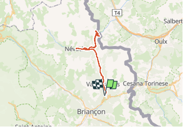

Length
48 km

Max alt
1808 m

Uphill gradient
995 m
Km-Effort
61 km

Min alt
1364 m

Downhill gradient
996 m
Boucle
Yes
Creation date :
2024-07-14 07:44:37.774
Updated on :
2024-07-14 11:03:31.239
2h37
Difficulty : Medium

FREE GPS app for hiking
 SityTrail
IGN / Geographical institutes
SityTrail Plus
The world is yours!
About
Trail Road bike of 48 km to be discovered at Provence-Alpes-Côte d'Azur, Hautes-Alpes, Montgenèvre. This trail is proposed by BELLETGE.
Positioning
Country:
France
Region :
Provence-Alpes-Côte d'Azur
Department/Province :
Hautes-Alpes
Municipality :
Montgenèvre
Location:
Unknown
Start:(Dec)
Start:(UTM)
317021 ; 4977738 (32T) N.
Comments