


Mulhouse centre ville

MAUVAGE Patrick
User
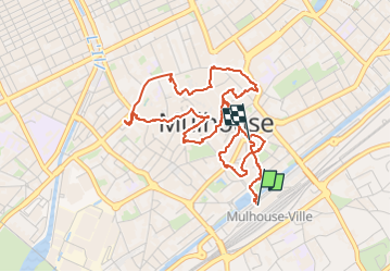

Length
5.1 km

Max alt
248 m

Uphill gradient
39 m
Km-Effort
5.6 km

Min alt
237 m

Downhill gradient
41 m
Boucle
No
Creation date :
2024-07-17 08:05:28.0
Updated on :
2024-07-17 19:46:39.557
1h16
Difficulty : Easy

FREE GPS app for hiking
 SityTrail
IGN / Geographical institutes
SityTrail Plus
The world is yours!
About
Trail Walking of 5.1 km to be discovered at Grand Est, Haut-Rhin, Mulhouse. This trail is proposed by MAUVAGE Patrick.
Photos


Positioning
Country:
France
Region :
Grand Est
Department/Province :
Haut-Rhin
Municipality :
Mulhouse
Location:
Unknown
Start:(Dec)
Start:(UTM)
375729 ; 5288996 (32T) N.
Comments