


balisage GR10U 2024

LouisROGER
User GUIDE
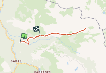

Length
14.5 km

Max alt
1974 m

Uphill gradient
1042 m
Km-Effort
27 km

Min alt
1108 m

Downhill gradient
588 m
Boucle
No
Creation date :
2024-07-17 05:35:14.551
Updated on :
2024-07-17 18:01:02.504
9h33
Difficulty : Very difficult

FREE GPS app for hiking
 SityTrail
IGN / Geographical institutes
SityTrail Plus
The world is yours!
About
Trail Walking of 14.5 km to be discovered at New Aquitaine, Pyrénées-Atlantiques, Laruns. This trail is proposed by LouisROGER.
Photos

Positioning
Country:
France
Region :
New Aquitaine
Department/Province :
Pyrénées-Atlantiques
Municipality :
Laruns
Location:
Unknown
Start:(Dec)
Start:(UTM)
710365 ; 4753544 (30T) N.
Comments