


2024-07-18_08h19m05_Roc_de_Four_Magnin_en_traversee

jpb83
User
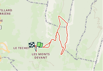

Length
8.4 km

Max alt
1618 m

Uphill gradient
621 m
Km-Effort
16.6 km

Min alt
1005 m

Downhill gradient
620 m
Boucle
Yes
Creation date :
2024-07-18 06:19:05.481
Updated on :
2024-07-18 06:24:24.372
3h46
Difficulty : Difficult

FREE GPS app for hiking
 SityTrail
IGN / Geographical institutes
SityTrail Plus
The world is yours!
About
Trail Walking of 8.4 km to be discovered at Auvergne-Rhône-Alpes, Savoy, Bellecombe-en-Bauges. This trail is proposed by jpb83.
Positioning
Country:
France
Region :
Auvergne-Rhône-Alpes
Department/Province :
Savoy
Municipality :
Bellecombe-en-Bauges
Location:
Unknown
Start:(Dec)
Start:(UTM)
279025 ; 5068712 (32T) N.
Comments