


ccc

chrispaquet
User

Length
1.8 km

Max alt
1518 m

Uphill gradient
106 m
Km-Effort
2.9 km

Min alt
1405 m

Downhill gradient
30 m
Boucle
No
Creation date :
2024-07-18 13:45:02.476
Updated on :
2024-07-18 14:17:10.497
32m
Difficulty : Easy

FREE GPS app for hiking
 SityTrail
IGN / Geographical institutes
SityTrail Plus
The world is yours!
About
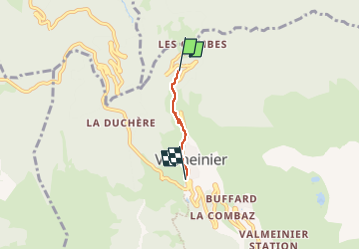
Trail Walking of 1.8 km to be discovered at Auvergne-Rhône-Alpes, Savoy, Valmeinier. This trail is proposed by chrispaquet.
Description
marche
Positioning
Country:
France
Region :
Auvergne-Rhône-Alpes
Department/Province :
Savoy
Municipality :
Valmeinier
Location:
Unknown
Start:(Dec)
Start:(UTM)
301973 ; 5007825 (32T) N.
Comments