


Sommet de Géruen par "les passages secrets"

Clo0413
User
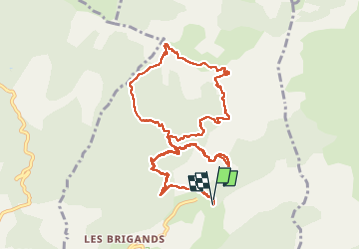

Length
13 km

Max alt
1880 m

Uphill gradient
862 m
Km-Effort
25 km

Min alt
1115 m

Downhill gradient
875 m
Boucle
Yes
Creation date :
2024-07-23 05:09:59.887
Updated on :
2024-08-08 07:53:41.886
5h34
Difficulty : Very difficult

FREE GPS app for hiking
 SityTrail
IGN / Geographical institutes
SityTrail Plus
The world is yours!
About
Trail Walking of 13 km to be discovered at Provence-Alpes-Côte d'Azur, Alpes-de-Haute-Provence, Hautes-Duyes. This trail is proposed by Clo0413.
Positioning
Country:
France
Region :
Provence-Alpes-Côte d'Azur
Department/Province :
Alpes-de-Haute-Provence
Municipality :
Hautes-Duyes
Location:
Unknown
Start:(Dec)
Start:(UTM)
274884 ; 4898150 (32T) N.
Comments