


olivieraron
User
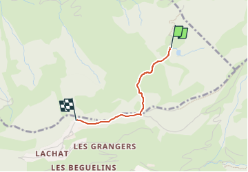

Length
1.5 km

Max alt
1499 m

Uphill gradient
156 m
Km-Effort
3.2 km

Min alt
1340 m

Downhill gradient
19 m
Boucle
No
Creation date :
2024-07-25 07:29:12.711
Updated on :
2024-07-25 07:29:12.711

FREE GPS app for hiking
 SityTrail
IGN / Geographical institutes
SityTrail Plus
The world is yours!
About
Trail of 1.5 km to be discovered at Auvergne-Rhône-Alpes, Savoy, Flumet. This trail is proposed by olivieraron.
Positioning
Country:
France
Region :
Auvergne-Rhône-Alpes
Department/Province :
Savoy
Municipality :
Flumet
Location:
Unknown
Start:(Dec)
Start:(UTM)
310242 ; 5076687 (32T) N.
Comments