


chapelle Sayarce st jean pied de port

taguette
User
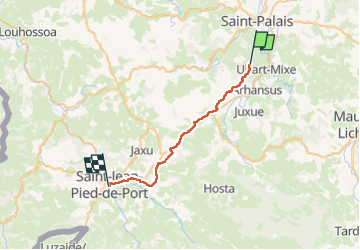

Length
28 km

Max alt
288 m

Uphill gradient
561 m
Km-Effort
36 km

Min alt
123 m

Downhill gradient
676 m
Boucle
No
Creation date :
2024-07-27 05:58:58.346
Updated on :
2024-07-27 15:14:59.753
8h15
Difficulty : Very difficult

FREE GPS app for hiking
 SityTrail
IGN / Geographical institutes
SityTrail Plus
The world is yours!
About
Trail Walking of 28 km to be discovered at New Aquitaine, Pyrénées-Atlantiques, Uhart-Mixe. This trail is proposed by taguette.
Positioning
Country:
France
Region :
New Aquitaine
Department/Province :
Pyrénées-Atlantiques
Municipality :
Uhart-Mixe
Location:
Unknown
Start:(Dec)
Start:(UTM)
658760 ; 4794222 (30T) N.
Comments