


La Preste les Conques (refuge)

patbt
User
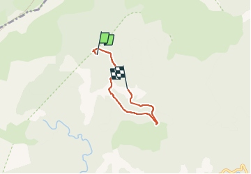

Length
4 km

Max alt
1737 m

Uphill gradient
65 m
Km-Effort
5.2 km

Min alt
1582 m

Downhill gradient
178 m
Boucle
No
Creation date :
2024-07-27 12:56:07.313
Updated on :
2024-07-27 16:13:46.344
3h17
Difficulty : Very easy

FREE GPS app for hiking
 SityTrail
IGN / Geographical institutes
SityTrail Plus
The world is yours!
About
Trail Walking of 4 km to be discovered at Occitania, Pyrénées-Orientales, Prats-de-Mollo-la-Preste. This trail is proposed by patbt.
Positioning
Country:
France
Region :
Occitania
Department/Province :
Pyrénées-Orientales
Municipality :
Prats-de-Mollo-la-Preste
Location:
Unknown
Start:(Dec)
Start:(UTM)
449782 ; 4698086 (31T) N.
Comments