


G4 Port de castet 2024

LouisROGER
User GUIDE
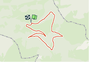

Length
9.4 km

Max alt
1137 m

Uphill gradient
303 m
Km-Effort
13.5 km

Min alt
865 m

Downhill gradient
303 m
Boucle
Yes
Creation date :
2024-07-26 07:47:40.97
Updated on :
2024-07-30 06:40:41.297
4h14
Difficulty : Difficult

FREE GPS app for hiking
 SityTrail
IGN / Geographical institutes
SityTrail Plus
The world is yours!
About
Trail Walking of 9.4 km to be discovered at New Aquitaine, Pyrénées-Atlantiques, Castet. This trail is proposed by LouisROGER.
Description
G4 port de castet 2024
Positioning
Country:
France
Region :
New Aquitaine
Department/Province :
Pyrénées-Atlantiques
Municipality :
Castet
Location:
Unknown
Start:(Dec)
Start:(UTM)
713291 ; 4771188 (30T) N.
Comments