


Ziburu1/2dur

yoye
User
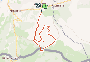

Length
9.6 km

Max alt
401 m

Uphill gradient
386 m
Km-Effort
14.8 km

Min alt
52 m

Downhill gradient
390 m
Boucle
Yes
Creation date :
2024-07-30 05:59:11.0
Updated on :
2024-07-30 09:45:06.701
3h02
Difficulty : Difficult

FREE GPS app for hiking
 SityTrail
IGN / Geographical institutes
SityTrail Plus
The world is yours!
About
Trail Walking of 9.6 km to be discovered at New Aquitaine, Pyrénées-Atlantiques, Urrugne. This trail is proposed by yoye.
Description
Dur moitié
Positioning
Country:
France
Region :
New Aquitaine
Department/Province :
Pyrénées-Atlantiques
Municipality :
Urrugne
Location:
Unknown
Start:(Dec)
Start:(UTM)
607992 ; 4798683 (30T) N.
Comments