


ballade Moyne

JPS73
User
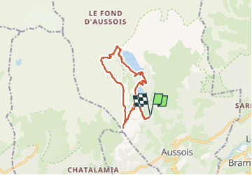

Length
12.7 km

Max alt
2425 m

Uphill gradient
732 m
Km-Effort
22 km

Min alt
1776 m

Downhill gradient
729 m
Boucle
Yes
Creation date :
2024-07-27 07:06:50.253
Updated on :
2024-07-30 14:28:14.149
4h07
Difficulty : Very difficult

FREE GPS app for hiking
 SityTrail
IGN / Geographical institutes
SityTrail Plus
The world is yours!
About
Trail Walking of 12.7 km to be discovered at Auvergne-Rhône-Alpes, Savoy, Aussois. This trail is proposed by JPS73.
Positioning
Country:
France
Region :
Auvergne-Rhône-Alpes
Department/Province :
Savoy
Municipality :
Aussois
Location:
Unknown
Start:(Dec)
Start:(UTM)
321718 ; 5012136 (32T) N.
Comments