Trail Walking Lelin-Lapujolle - St Jacques Étape 29 réalisée  - Photo

St Jacques Étape 29 réalisée

© OpenStreetMap contributors
Length
Length
24 km
Max alt
Max alt
171 m
Uphill gradient
Uphill gradient
239 m
Km-Effort
Km-Effort  
27 km
Min alt
Min alt
78 m
Downhill gradient
Downhill gradient
206 m
Boucle
Boucle
No
Creation date :
2016-03-09 00:00:00.0
Updated on :
2016-03-09 00:00:00.0

(0 Reviews)

Walking
Walking
6h09
Difficulty : Very easy

Scan this QR Code to open this trail in the SityTrail application

FREE GPS app for hiking

Logo SityTrail SityTrail

IGN / Geographical institutes

Download SityTrail from the App Store Download SityTrail from Google Play

Logo SityTrail SityTrail World

The world is yours!

Download SityTrail from the App Store Download SityTrail from Google Play Download SityTrail on Huawei AppGallery

About

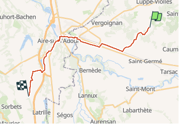
Trail Walking of 24 km to be discovered at Occitania, Gers, Lelin-Lapujolle. This trail is proposed by Jean-MarieFaux.

Description

De Manciet à la D 62 en passant par Aire sur Adour. Étape très plate avant Aire sur Adour. Très beau Lac Brousseau. Retour après au longue ligne droite entre les champs de maïs

Elevation profile

Positioning

Country:
France
Region :
Occitania
Department/Province :
Gers
Municipality :
Lelin-Lapujolle
Location:
Unknown
Start:(UTM)
730563 ; 4844049 (30T) N.

Trails nearby

Trail Walking Lanne-Soubiran - CC_Velay_FA_24_Lanne-Soubiran_Aire-Adour_20081109 - Photo
Walking
patrickdanilo

Walking

Easy
Lanne-Soubiran, Occitania, Gers, France
25 km | 29 km-effort
6h 15min
No
Trail Walking Lanne-Soubiran - Compostelle 22 1er Etape - Photo
Walking
Anne-Marie Duret

Walking

Easy
Lanne-Soubiran, Occitania, Gers, France
18.8 km | 21 km-effort
4h 51min
No
Trail Walking Lanne-Soubiran - Aire sur l'Adour  - Photo
Walking
cutter

Walking

Easy
Lanne-Soubiran, Occitania, Gers, France
22 km | 25 km-effort
9h 40min
No
Trail Walking Arblade-le-Bas - OR-6947886--Arblade-le-Bas:Airblade le bas-mirmont-sensacq-8 - Photo
Walking
Compostel61

Walking

Very easy
Arblade-le-Bas, Occitania, Gers, France
26 km | 30 km-effort
6h 34min
No
Trail Walking Lanne-Soubiran - presbytère-Aire sur l'Adour  - Photo
Walking
bernard.bonafous@free.fr

Walking

Very difficult
Lanne-Soubiran, Occitania, Gers, France
21 km | 23 km-effort
4h 46min
No
Trail Walking Lanne-Soubiran - 70_19_02 Lanne-Soubiran Aire Sur  - Photo
Walking
jeanlucien

Walking

Easy
Lanne-Soubiran, Occitania, Gers, France
19.8 km | 23 km-effort
5h 7min
No
Trail On foot Lanne-Soubiran - 2021 J2 septbre Compostelle Lanne Soubiran= Aire sur l'Adour - Photo
On foot
philippevh

On foot

Medium
Lanne-Soubiran, Occitania, Gers, France
21 km | 24 km-effort
5h 22min
No
Trail Walking Lelin-Lapujolle - lanne  aire - Photo
Walking
ghislainem

Walking

Difficult
Lelin-Lapujolle, Occitania, Gers, France
13.3 km | 14.7 km-effort
4h 56min
No
Trail On foot Lanne-Soubiran - 20210618- Etape 26- Lanne Soubiran- Aire sur Adour - Photo
On foot
ghislainem

On foot

Medium
Lanne-Soubiran, Occitania, Gers, France
21 km | 24 km-effort
5h 21min
No


Close
My subscriptions