


20240731_113040_cohennoz

olivieraron
User
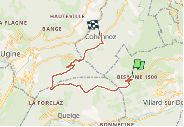

Length
12.4 km

Max alt
1575 m

Uphill gradient
118 m
Km-Effort
16.1 km

Min alt
926 m

Downhill gradient
753 m
Boucle
No
Creation date :
2024-07-31 09:31:16.0
Updated on :
2024-07-31 09:31:17.901

FREE GPS app for hiking
 SityTrail
IGN / Geographical institutes
SityTrail Plus
The world is yours!
About
Trail of 12.4 km to be discovered at Auvergne-Rhône-Alpes, Savoy, Villard-sur-Doron. This trail is proposed by olivieraron.
Positioning
Country:
France
Region :
Auvergne-Rhône-Alpes
Department/Province :
Savoy
Municipality :
Villard-sur-Doron
Location:
Unknown
Start:(Dec)
Start:(UTM)
305719 ; 5068027 (32T) N.
Comments